MORRO BAY STATE PARK
Morro Bay State Park features lagoon and natural bay habitat. The bay?s most prominent landmark is Morro Rock. The park has opportunities for sailing, fishing, hiking, and bird watching. The park museum has exhibits cover natural features and cultural history, Native American life, geology, and oceanography. The park also has a colorful marina and an 18-hole public golf course. On the bay?s northeast edge is a pristine saltwater marsh that supports a thriving bird population.
Anglers can enjoy saltwater fishing from the shore or by boat, targeting species like halibut, rockfish, and surfperch. Freshwater enthusiasts may fish in the park's lagoon for trout and bass. Fishing licenses are required for those 16 years of age and older. The area also offers a public pier with no license needed to cast a line into the bay waters where mackerel and jacksmelt are common catches.
Morro Bay State Park is located near Atascadero, Grover Beach and Los Osos
Morro Bay State Park offers scenic picnic spots with tables, BBQ grills, and views of the bay and Morro Rock.
Black Hill Trail
To Black Hill summit is 3 miles round trip with 600-foot elevation gainA series of nine peaks between San Luis Obispo and Morro Bay originated as volcanoes beneath the sea that covered this area some fifteen million years ago. After the sea and volcanic explosions subsided, erosion began dissolving the softer mountain material around the volcanic rock and left nine volcanic peaks standing high above the surrounding landscape. These volcanic plugs include Hollister Peak and famed Morro Rock.
Black Hill, the last peak in the volcanic series before Morro Rock, has a trail that tours a little of everything?chaparral, eucalyptus, oaks, pines, and coastal shrubs. From the mountain?s 640-foot summit, you can view the Morro Bay Estuary, the sand spit, and the hills of nearby Montana de Oro State Park.
Directions to trailhead: Follow Coast Highway for 12 miles north of San Luis Obispo to the Los Osos-Baywood Park exit just before Morro Bay. Turn south on South Bay Boulevard and go 0.75 mile to Morro Bay State Park entrance. Bear left on the first fork beyond the entrance, heading one mile to the campground entrance directly across from the state park marina lot, where you should park. Park along the first crossroads inside the campground. Walk up the campground road to join the trail.
The hike: Walk up the group camp access road, past the group camp rest-room. Follow the trail under the power lines between the golf course on the left and Chorro Group Camp on the right, cross a paved road and begin ascendingthe mountain. A mile from the trail-head, there?s a junction. Bear left. The route becomes steeper, passing first through coastal shrubs then conifers. The trail passes a water tank, then switchbacks to the summit.
After enjoying the fine view, you may return the same way or return via the east fork of the old exercise trail by backtracking 0.5 mile to the trail junction, then heading straight (east). You?ll discover a eucalyptus grove, where monarch butterflies cluster. Cross a golf course road and rejoin the eastern section of the Exercise Trail, which returns you to the trailhead.
Offers diverse habitats like saltwater marsh, mudflats, and coastal scrub. Home to over 250 bird species. Popular for spotting herons, egrets, peregrine falcons, and various waterfowl. Winter brings in migratory birds such as brant geese. The Heron Rookery Natural Preserve is nearby with nesting great blue herons and double-crested cormorants.
Museum of Natural History:
A visit to the Central Coast of California is not complete without a stop at the Museum of Natural History in Morro Bay State Park. The museum offers activities for all ages: nature walks, exhibits, lectures, puppet shows, videos, docent led tours and special events.
Visit the Chumash garden along the side of the museum and learn how the Chumash used native plants of this area in their daily lives.
The Museum of Natural History is within minutes of the Heron Rookery, Morro Bay State Park, Montana de Oro State Park, the El Moro Elfin Forest and Audubon's Sweet Springs Nature Preserve. The museum overlooks Morro Bay which is both a State and National Estuary.
Location - Directions
From San Luis Obispo take Highway 1 north to the Los Osos - Baywood Park offramp. Turn left, go about 1 mile and turn right into the state park.
From the South, take Highway 101 northbound to the Los Osos - Baywood Park offramp. Turn left toward Los Osos and travel about 10 miles to South Bay Blvd., then turn right and go about 3 miles to the state park entrance.
The Museum of Natural History is in the park. Drive about one mile, past the campground and the marina, then turn left into the museum parking lot.


 Share Your Morro Bay State Park Photos (click here)
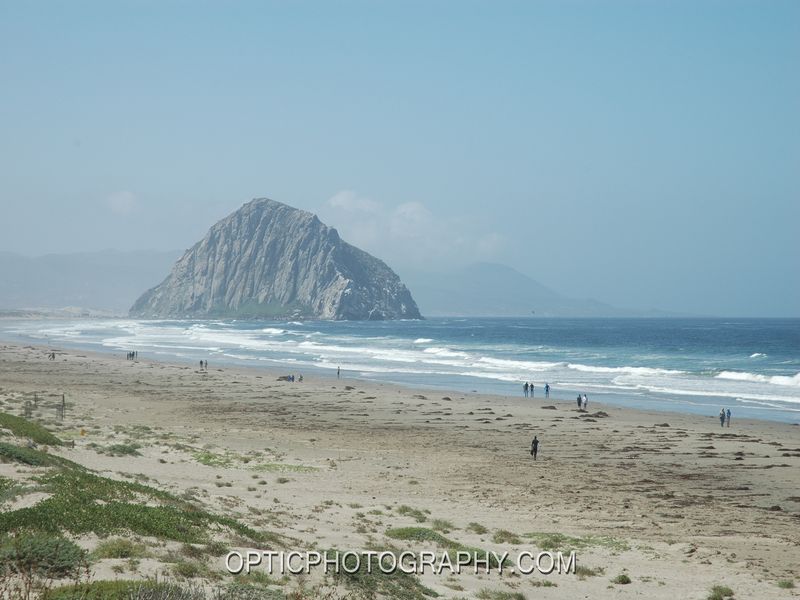