MORRIS HILL CAMPGROUND
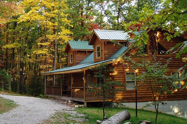
Morris Hill is a peaceful, rustic campground for groups of family and friends. The family campground is a family-friendly destination perched on a ridge above Lake Moomaw. Kids can have fun at the playground while older generations sit back and relax in the shade. The group sites accommodate up the 25 guests with space for up to eight tents. Campers can enjoy the wonders of camping with simple pleasures like s'mores on the campfire, berry picking in the woods, and watching for waterfowl and wildlife like deer. The convenient location near Lake Moomaw and sandy swim beaches, a fishing pier, boat ramp, and hiking and biking trails makes Morris Hill a popular spot.Family Campground Most sites will fit any size RV. Campsite amenities include flush toilets, hot showers, a playground and drinking water. Group Sites There is no water or electricity. Two fully accessible vault toilets, picnic tables and a group grill are on each group site. Coles Point Boat Ramp, the nearest boat ramp to Morris, is less than two miles away.The campground sits on a ridge overlooking Lake Moomaw. It is about a half-mile from the south end of the lake. Lake Moomaw, which flows from the Jackson River, is a cold-water 2,530-acre lake with an inviting swimming beach.
Morris Hill is part of the George Washington and Jefferson National Forests which spans across Virginia and parts of West Virginia and Kentucky. These forests protect 40 species of trees that are mostly Appalachian hardwood and mixed pine-hardwood forests, 60 species of mammals and 200 species of birds.Head downstream of the Jackson River for fly fishing, canoeing, rafting and kayaking. A half hour east of the lake is Hot Springs, Virginia, a quaint village known as a rural resort town.
An inviting swimming beach at Coles Point attracts many visitors. About less than a mile from the campground is a fishing pier where anglers seek brown and rainbow trout, bass and crappie. Back Creek is also nice for trout fishing. Hikers enjoy the Morris Hill Bike Trail and Fortney Loop Trail.
 Beartree Campground
Beartree offers a relaxing, family-friendly atmosphere and a variety of recreational activities. Located in the Mount Rogers National Recreation Area, the campground boasts a sprawling layout with both group and individual campsites. A small creek flows through the campground, offering a refreshing spot to wade and fish.
Beartree Lake is also located
....moreBolar Mountain Recreation Area Bolar Mountain Recreation Area is a great destination for visitors looking for a fun getaway on Lake Moomaw. The area provides plenty of outdoor activities, including boating, fishing, camping and hiking. There is little to no cell service, so be ready to disconnect
Boating, canoeing, water skiing and relaxing on the beach are popular activities at the
....more Cave Mountain Lake Campground Cave Mountain Lake Family Camp is nestled in the Blue Ridge Mountains of Virginia, and welcomes visitors to enjoy the rustic and peaceful getaway. Easy access from the interstate and close proximity to historic Lexington and the Natural Bridge State Park make Cave Mountain Lake an ideal destination.Lexington, Virginia, just 20 minutes away, is home to
....more Collins Cove Horse Camp Collins Cove is a first-come, first-served, primitive campground. Each of the 10 camping units have a wooden picnic table, fire ring, and hitching rails. This grassy campground is shaded with hardwoods, hemlocks, and pines and offers direct access to horse trails. Centrally located garbage bins and a vault toilet are available. A creek is located
....more Elizabeth Furnace Family Campground The charming family campground sits in the Shenandoah Valley along Passage Creek, a tributary of the North Fork Shenandoah River. The area is part of the George Washington and Jefferson National Forests which spans across Virginia and parts of West Virginia and Kentucky. These forests protect 40 species of trees that are mostly Appalachian hardwood and
....more Grindstone Campground Grindstone Campground is tucked in the Fairwood Valley among pastures and wooded hillsides. The surrounding Mount Rogers National Recreation Area provides endless opportunities for fun and relaxation in the nature setting. The Campground will be closed until further notice due to facility repair needs. Opossum Loop will be open for tent campers. There will
....more Hurricane Campground Hurricane Campground is one of the best kept secrets in southwest Virginia. Located along a rushing mountain stream under the shade of hemlock and rhododendron, this campground offers a peaceful setting for those looking to relax as well as visitors looking for outdoor adventure.
From the campsite, hikers can access many trails including the
....more McClintic Point Primitive Campground Enjoy the easygoing, peaceful vibe of McClintic Point's rustic campground set among scattered trees and open fields. This angler's paradise provides plentiful shoreline fishing and some lakefront campsites.Head to the quaint town of Warm Springs for restaurants or to visit the Bath County Historical Society.
Boating, canoeing, water skiing and and
....more Raccoon Branch Campground Raccoon Branch Campground, nestled at the base of Dickey Knob, offers scenic mountain views, hiking trail access from campsites and cool mountain streams. Campers can access Dickey Creek and the Raccoon Branch from the campground. The most notable time to visit is fall, when the trees boast gorgeous fall foliage.
With a location just 11 miles from
....more Sherando Lake Recreation Area Sherando Lake Recreation Area's Family Campground provides an ideal camping destination. It is situated in the Blue Ridge Mountains and is known locally as the jewel of the Blue Ridge Mountains, where visitors enjoy hiking, picnicking in the shade, fishing in the lakes, or swimming and relaxing on the sandy beach.The campground is divided into three loops
....more Stony Fork Campground Stony Fork, tucked in a dense forest setting, is located at the foot of Big Walker Mountain beside the Big Walker Mountain Scenic Byway. The East Fork of Stony Fork Creek winds through the campground, providing a serene setting for trout fishing and water play for visitors at the welcoming campground.
The 1 mile Stony Fork Nature Trail takes campers
....more Trout Pond Recreation Area Trout Pond Recreation Area boasts two bodies of water, Rock Cliff Lake and Trout Pond. Relax on a sandy mountain beach or fish for stocked trout while relaxing along the cool waters of Rock Cliff Lake.
Trout Pond, home to native Brook trout, is the only natural lake in West Virginia. A designated swimming area, easy lakeside trails, and a children's
....more


 Share Your Morris Hill Campground Photos (click here)