ANNIE AND ABEL VAN METER STATE PARK
The state of Missouri and its principal river were both named after a tribe of Native Americans, known by the French explorers as the 'Oumessourit' or Missouri Indians, that once lived in the area of Van Meter State Park. Today, the park provides outdoor recreational opportunities and interprets the area landscape and the Native Americans who found it to be bountiful.
For many centuries, Native American hunters traversed the nearby marshes and prairies and the deep ravines and narrow ridges, locally known as the Pinnacles. In 1673, French explorers Jacques Marquette and Louis Jolliet composed a map that located a Missouri Indian village at the Great Bend of the Missouri River.
Van Meter State Park features remnants of this early village site. A hand-dug earthwork, known as the Old Fort, and several burial mounds lie within park boundaries. The area's Native American history is also interpreted inside the park's visitor center through exhibits and a large mural depicting the life of the Missouri Indians.
For outdoor enthusiasts, the park features hiking trails, an 18-acre lake for fishing, a campground and the Oumessourit Natural Area, which consists of a fresh-water marsh, fens and bottomland and upland forests. Picnic sites and two picnic shelters are nestled under lofty trees.
The Missouri Indians first came to the attention of Europeans through the account left from the Louis Jolliet and Father Jacques Marquette expedition in 1673. On the Marquette map, they are referred to as the "Oumessourit." This is the Illinois name for them, and can be translated as the "people of the dugout canoes." It is not what the Missouri called themselves, but the name would remain.
The Missouri were not newcomers to the area. While the Osage and Illinois had been pushed westward from the east after Europeans started settling the East Coast, the Missouri had been here for centuries. The earliest Oneota (ancestral Missouri) site in the area dates from A.D. 1250, and the Missouri Indian village (the Utz site) dates from as early as A.D. 1450.
The Missouri were typical prairie dwellers. They lived in large rush mat-covered houses with from 15-25 people in each. These longhouses were fairly widely spaced across the village, which contained approximately 5,000 people at first European contact. The people grew corn, beans and squash in small agricultural plots, probably in the bottomlands. The crops were planted in the spring, and the people stayed in the village through the early stages of the crops. In June, they left on the summer hunt, principally seeking bison. In August, they returned to harvest the crops. While most remained for the rest of the year, the men often left on other hunting trips through the winter.
The Old Fort, an irregular, double-ditched earthwork located in the park, was built by the ancestral Missouri Indians (Oneota). Archaeological investigations have not yet revealed the nature and purpose of this interesting man-made feature of the landscape.
Because the Missouri were the first group encountered on the Missouri River, they were visited early by the French. Probably the first direct contact with Europeans came in 1680 or 1681 when two traders were captured by the Missouri and taken to their village. The first recorded encounter was in 1682 when French explorer Sieur de La Salle, Robert Cavelier, was on his way south to the mouth of the Mississippi River. His party came upon a group of Tamaroa (Illinois Indians) and some Missouri on their way to conduct a raid on the Osage Indians.
About 1715, the Little Osage Indians moved from western Missouri and established a village near the Missouri to have greater access to fur traders. The Missouri often stopped traders from going upriver to obtain guns, lead and other items from them. Following the Big Osage and Little Osage, the Missouri contributed significantly to the fur trade in St. Louis.
Annie and Abel Van Meter State Park offers basic and electric campsites.


 Share Your Annie and Abel Van Meter State Park Photos (click here)
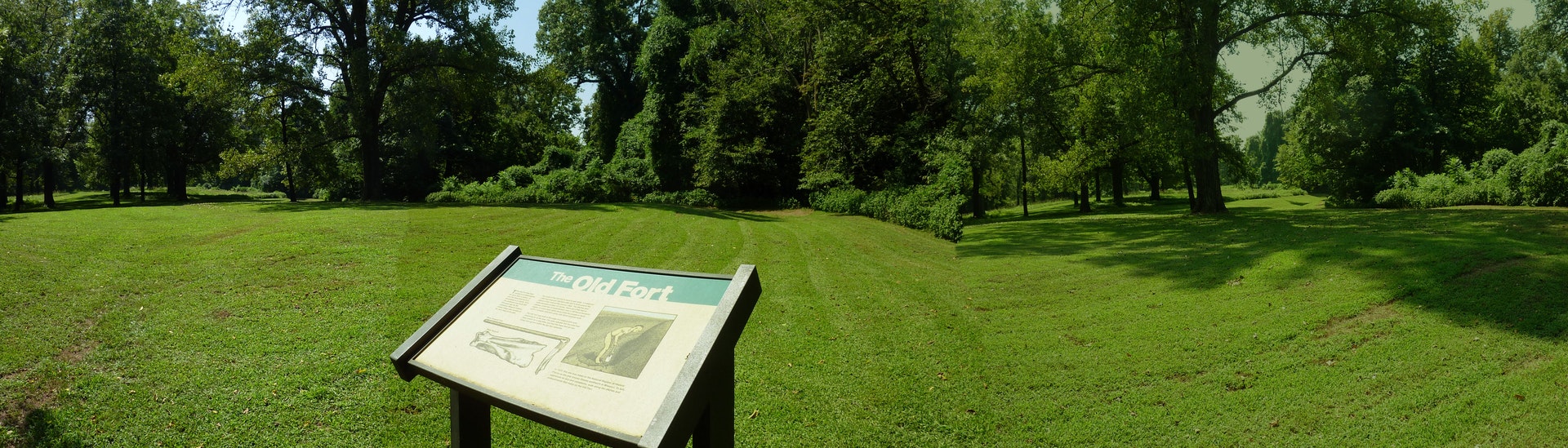