State Park Location Maps:
 (click here to zoom and navigate local map)
 (click here to zoom and navigate regional map)
View TOPO Maps!
Get directions to this park:
State Park Photo Gallery:
volunteer positions open
State Park Link: Woodford State Fish & Wildlife Area
Nearby Parks: Marshall State Fish & Wildlife Area Cameron National Wildlife Refuge Henderson County State Fish & Wildlife Area Lowden-Miller State Forest Fort Creve Coeur State Park
|
| State Park Contact Information: |
 |
Woodford State Fish & Wildlife Area R.R. 1 Low Point, Illinois 61545 Phone: 309-822-8861 Email: dnr.R1Parks@illinois.gov
|
| Adopt-A-Park Contacts: |
 |
Photography: add your photos
|
|
| State Park Overview: |
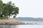
 | Woodford State Fish and Wildlife Area is a picturesque area along the east side of the Illinois River. Among its features are many artesian wells, which make the manmade channels an excellent winter fishing area. The 2,900-acre site, of which 2,462-acres are water, is a favorite stopping point for waterfowl during migration. |
| Nature of the Area: |
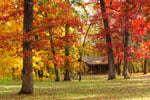
| The area comprises bottomland forest and backwater lakes of the Illinois River and features a wide variety of fauna and flora. Cottonwood, silver maple and willow cover much of the low-lying land. Deer, raccoon, muskrat, mink and beaver find this habitat to their liking and sometimes can be observed at dawn and dusk. Tall and stately great blue herons also are found in large numbers on the backwaters, and during winter it is not unusual to see a bald eagle soring above the frozen lakes or perched atop a snag.
A major waterfowl refuge of 1,400 acres exists on the area. While less attractive to wildlife due to heavy siltation in recent years, backwater lakes still attract large flights of waterfowl during migration. However, only wood ducks and Canada geese commonly nest and raise their young here. Hawks and owls, especially barred owls, are common to the area, as are an assortment of songbirds and woodpeckers. |
| Reviews By Park Visitors: |
 | Be the 1st to Review Woodford State Fish & Wildlife Area. You can rate it, post a comment on it, or do both. |
 | |
| Camping: |
| Sites for tents and trailers are provided. Water pit privies and a sanitary dump station are available. Due to periodic flooding of the Illinois River, it is advisable to call ahead and check on conditions before you visit. |
| Trails: |
| More than 3 miles of marked trails are available for hiking, cross-country skiing and hunter access from Dec. 15-Oct. 1. Because the trail area is composed of levees used as a waterfowl management area, trails are closed during fall migration. No bicycles or other vehicles are allowed on the trails. |
| Picnicking: |
| The area provides a day-use area with picnic tables, stoves and a shelter. |
| Boating: |
| The site provides boat docks and a public boat ramp. There is no horsepower limit. Large boats are unable to navigate the shallow backwater lakes. |
| Fishing and Hunting: |
| Fishing
The fishing water consists of a broad expanse of the Illinois River known as Upper Peoria Lake and Goose Lake, plus 3,475 feet of manmade fishing channels. These channels provide excellent bullhead and crappie fishing in the late winter and early spring because the wells keep the channels free from ice.
Hunting
Squirrel hunting is allowed and designated blind sites are offered for waterfowl hunting. |
 | |
| |
|  | Advertise your park related business on stateparks.com
...vacation cabin, weekend getaway, log cabin rental, romantic cottage, vacation home, resort, hotel, motel, bed and breakfast, country inn, campground, RV park, horseback riding stable, canoe livery, river rafting, outfitting, sporting goods store, guide service, RV rental, etc read more.... |
|
| Related Links: |
| Directions: |
| Woodford State Fish & Wildlife Area is located on State Rt 26 and can be reached from either I-80 from the north or I-74 from the south. From I-80, take I-39 south for approximately 25 miles to State Rt 17 west for 20 miles to Lacon. Than take State Rt 26 south for 10 miles. The entrance is on the right and is well signed. From I-74 at East Peoria, take State Rt 116 north for 5 miles to State Rt 26 north for 15 miles. The entrance is on the left and is well signed. |
 |
| |
| |
|