STANISLAUS NATIONAL FOREST
STANISLAUS NATIONAL FOREST19777 Greenley Road
Sonora, California 95370
(lat:38.2502 lon:-120.0013)

Email:

Located in central California, lies the Stanislaus National Forest. You can fish in over 800 miles of rivers and streams, enjoy a comfortable cabin, stay in a campground, or hike into the backcountry seeking pristine solitude. You can swim near a sandy beach or wade into cold clear streams cooling your feet while lost in the beauty of nature, raft the exciting and breath-taking Tuolumne River, or canoe one of the many gorgeous lakes. You can ride a horse, a mountain bike or a snowmobile. Clearly the choice is yours in the special places of the Stanislaus National Forest.
The USDA Forest Service celebrated its 100th anniversary on July 1, 2005. On this date 100 years ago, the Forest Service was created as an agency with a unique mission: to sustain healthy, diverse, and productive forests and grasslands for present and future generations. The creation of the Forest Service initiated a century of change in managing public forests and grasslands, with introduction of a new conservation ethic and professional workforce to carry it forth. As the agency celebrates its centennial, we are asking the public and our partners to join us in celebrating their national forests and connection with these public lands.
The first forest reserves were set aside beginning in 1891 and were administered by the Department of the Interior's General Land Office. Conservationists of the day, including John Muir founder of the Sierra Club, fiercely debated over who should manage these reserves.
Early in 1905, Gifford Pinchot, then the chief of the Department of Agriculture's Bureau of Forestry, began gathering support for transferring the forest reserves from the Department of the Interior to the Department of Agriculture. Pinchot was a firm believer that the nations' forest should be a sustainable source of lumber and other resources needed by the growing nation.
On July 1, 1905, President Theodore Roosevelt changed the Bureau of Forestry to the USDA Forest Service; he appointed Gifford Pinchot as the first chief forester. Two years later, these forest reserves were named "national forests" in order to signal an emphasis on the "wise use" of these public lands.
The creation of the Forest Service introduced a new conservation ethic that was different than that of any other land management agency. Its mission, "Caring for the Land and Serving People," focuses on multiple use and strives to sustain healthy, diverse, and productive forests and grasslands today and for future generations.
Day-UseFishingyes
Huntingyes
Hiking Trailyes
Picnickingyes
Stanislaus National Forest is
Biking:
Many trails on the Stanislaus National Forest are open to mountain bikes. By law all Wilderness is closed to mechanized travel. To insure continued access to the broadest array of riding opportunities, cyclists need to consider other road and trail users and avoid riding when and where resource damage will result. Off-trail riding causes vegetation and soil damage and as a result is not allowed.
Hiking:
quamarine lakes and streams, delicate wildflowers, spectacular vistas, unique geological formations, and other scenic wonders await hikers and nature lovers in the Stanislaus National Forest. Forest trails give travelers a variety of opportunities to experience the abundance of natural beauty found on the Stanislaus. Many of them appear on the Forest recreation map, Emigrant Wilderness topographic map, or Carson-Iceberg Wilderness topographic map available at Forest Offices. Hikers, horseback riders, and backpackers have 480 miles of trails, and over 1000 miles of un-surfaced roads available for their use and enjoyment.
Please be prepared for trail conditions that vary from well maintained to un-maintained. Whether your hiking trip will last an hour or an entire day, wear comfortable walking shoes appropriate for the season. Carry water and a good map of the area. Let someone at home know where you are going.
Please be aware of your impact on the natural environment and practice no-trace hiking and camping techniques at all times. If you plan to bring your pet, keep it on a leash and under control to help minimize the publics concern regarding safety, sanitation, and the threat to wildlife. Please pack out any trash you may have so others may enjoy a completely natural outdoor experience. Smoking while hiking is allowed only during winter and early spring (November through April), when vegetation is green.
Horseback Riding:
One of the most pleasurable ways to see the Stanislaus National Forest is on horseback. Approximately 400 miles of trails are suitable for riding, with several areas available for base camps. Regulations regarding group size and stock handling in the Wilderness are available at Forest Service offices and at trailheads.
Lower elevation riding and camping is available on the Mi-Wok (lower Highway 108) and Groveland (Highway 120) Ranger Districts. Riding and camping areas on Mi-Wok include Thompson Meadow, Bourland Meadow, Reynolds Creek, Deer Creek, and Camp Clavey. On Groveland, you can ride and camp at Andersen Valley, and Kibbie Ridge. The area south of the Cherry Lake Dam is available for camping with horses.
Higher elevation riding and camping is available on the Summit (upper Highway 108) and Calaveras (Highway 4 area) Ranger Districts. On Summit, riders camp at the Clark Fork Horse Campground. Day rides into the Carson-Iceberg Wilderness are possible from Clark Fork. On Calaveras, riders camp at Highland Lakes Campground and Pacific Valley Campground. Day rides into the Carson-Iceberg and Mokelumne Wildernesses are possible.
A Wilderness Permit is required for overnight stays in the Carson-Iceberg, Mokelumne, and Emigrant Wildernesses. These permits are issued free of charge. Special livestock-use rules will be attached to your wilderness permit. Be familiar with wilderness regulations-whether for day or overnight use. Other areas suitable for traveling and camping with livestock include Eagle Meadow, Fence Creek, Herring Creek, and the Emigrant Wilderness. If your riding group is larger than 20 people, please apply for a special-use permit for non-wilderness large group use from the Ranger District office in the area where you plan to travel.
From Sonora, the forest can be reached via state highway 120. From Merced, state highway 140 will lead you to the southern end of the forest.


 Share Your Stanislaus National Forest Photos (click here)
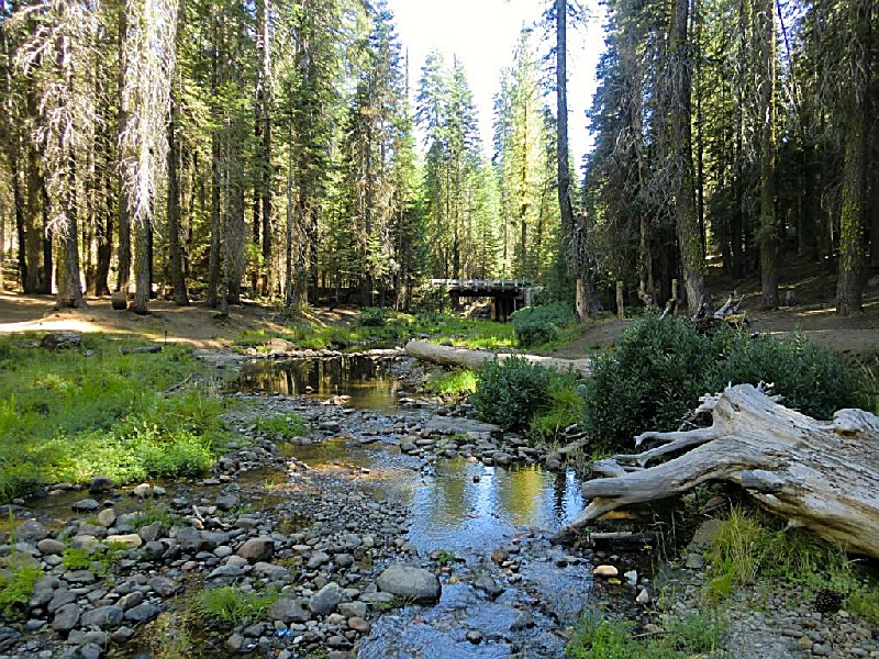