RED HILLS STATE PARK
For wildflowers, fresh foliage and soothing breezes in the spring...picnicking, camping, hiking, boating and fishing in the summer...appreciating the brilliant hues of autumn's colorful plumage...or ice skating and ice fishing in the brisk, blue winter...Red Hills State Park is waiting for you.
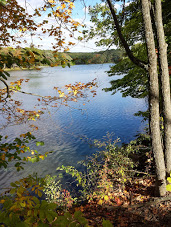
In southeastern Illinois midway between Olney and Lawrenceville on U.S. 50, Red Hills is a carefully preserved and maintained 948-acres of high wooded hills, deep ravines, captivating meadows and year-round springs. It's the perfect setting for natural relaxation and outdoor activities. The sparkling 40-acre lake is ideal for fishing and boating.
Dominated by Red Hill itself -- the highest point of land between St. Louis and Cincinnati -- and the 120-foot tower and cross rising from its summit, this unspoiled sanctuary from everyday life provides a great opportunity to relax and rediscover nature.
An open-air tabernacle at the base of the tower -- financed and constructed by area residents cooperating with an interdenominational council -- services are held on Sunday evening during the summer. A popular activity since 1943 has been the annual Easter sunrise services.
A satellite area of the park, the 565-acre Chauncey Marsh Nature Preserve, contains the best remaining example of what is called a Wabash Border Marsh Ecosystem, with marshes, dry and wet prairie, lush bottomland forest and thriving riverline communities. During late July and early August beautiful pink and white hibiscus and hairy rose mallow are in bloom.
Veterans' Point is a one-quarter acre parcel of land that is available to local veteran groups to honor ex-servicemen of all wars and to provide a place for their gatherings.
The park is an important historical crossroad, the western most edge of the first land in Illinois ceded by Native Americans to the United States. The borderline runs through the park from southwest to northeast, and was set by a treaty made in 1795 at Greenville, Ohio, by General Anthony Wayne whereby Native Americans relinquished all claims to the land northwest of the Ohio River and east of a specified line. The area was called Vincennes Tract. The western boundary running through the park was known as the Indian boundary line and is marked by decided jogs which corresponded to the original survey line.
The area was bisected by the Old Cahokia Trace, commonly known as the "Trace Road," which ran east and west just north of what is now U.S. 50, and was for many years the principal route from historic Vincennes, IN, to St. Louis and the west.
A dam constructed across Muddy Creek, a tributary of the Embarras (pronounced "Ambraw") River in 1953 created the 40-acre lake with a maximum depth of 30 feet and 2.5 miles of shoreline.
Since then, the park has grown to its present size, and development and improvement of its recreational facilities has been continuous.
Day-UseFishingyes
Huntingyes
Hiking Trailyes
Swimming Beachyes
Bike Trailsyes
Bridle Trailsyes
BoatingLaunch Rampsyes
CampingPrimitiveyes
Electric Sitesyes
Water/Electric Sitesyes
WinterActivitiesyes
For longer stays, there are more than 100 Class A campsites with vehicular access that provide electricity, a sanitary dump station, water and access to a modern handicapped-accessible building with showers and flush toilets. Some sites are pull-through with 50 amp service.
Handicapped sites are also available. In addition, there is a primitive tent camping area, rent-a-camp cabin, an equestrian campground and, in the North Park, a youth group tent camping area. Camping permits must be obtained from the park staff.
The restaurant is open year-round offering a spectacular four seasons overlook of Red Hills Lake and the surrounding hardwood forest. Fine dining is enhanced by the rustic atmosphere of a rural decor, antiques and creative seasonal decorations. The Holiday Banquet Room provides dining for an additional 50 guests and can be booked for private parties and meetings. Visitors to the Trace Inn will also enjoy a unique craft, collectibles, and antique shop. For more information call (618) 936-2352 or visit www.redhillstraceinn.com


 Share Your Red Hills State Park Photos (click here)