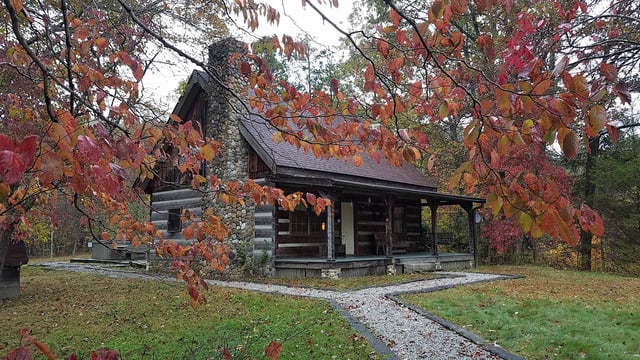
Save
You must be signed in to save park lists.
Your Park Lists
add New List
Add Photo
You must be signed in to add photos.
state route ranger badge
Ohio
27

Ohio State Parks

responsive menu icon
USA Parks
Ohio
Southeast Ohio Region
Perry State Forest
Cardinal © stateparks.com
Cardinal
Afternoon Hike © stateparks.com
Search
Availability
Calendars
Availability Search
PERRY STATE FOREST
PERRY STATE FOREST
Somerset, Ohio   43783
(lat:39.7755 lon:-82.1986) map location

Phone: (740) 674-4035
Whether you come to Perry to Ride APVs (all purpose vehicles), go horseback riding, hunt or just visit, you will have an enjoyable state forest experience. Much of Perry State Forest was strip mined for coal prior to existing reclamation law, resulting in very rugged, sometimes barren terrain. Since the state acquired the area in 1961, some reclamation has been accomplished, including a large area along CR 48. Several reforestation and test tree planting have been established on the forest. Note: The AVP area is open from April 2 through November 30. The Perry APV area is the most popular public riding area in Ohio. Miles of challenging trails are open. Picnic tables and latrines are provided at the parking area. Perry State Forest has a very scenic, day-use bridle trail system. Parking for horse trailer rigs is provided along County Road 48. The Miles Lake water is suitable for horses. The diversity of forest cover encourages a variety of wildlife species and hunting opportunities.
History of the Area
Perry State Forest, located in southeastern Ohio, has a long history dating back to the early 1900s. It was established primarily for the purposes of reforestation and timber production.

In the late 1800s and early 1900s, much of Ohio's forested land had been heavily logged, leading to ecological and economic concerns. As a result, the Cleveland and Hocking Valley Railway Company, under the leadership of its president and founder Thomas C. Mendenhall, sought to acquire lands for reforestation and timber cultivation.

In 1908, the Ohio General Assembly authorized the purchase of land in Hocking and Perry counties to develop a state forest. With funds provided by the railway company and support from conservation organizations, the state acquired approximately 4,500 acres of logged-over farmland, strip mine lands, and abandoned mining territory to establish Perry State Forest.

The initial goal was to re-establish a productive forest by planting trees, primarily hardwoods such as oak and hickory. The first planting took place in 1909, and the forest gradually expanded over the years through additional land acquisitions and reforestation efforts.

During the Great Depression in the 1930s, the Civilian Conservation Corps (CCC) played a significant role in developing Perry State Forest. CCC workers undertook extensive forest management projects, including building fire towers, trails, bridges, and recreational facilities. Many of these infrastructure projects are still present in the forest today.

Perry State Forest has evolved into a multi-use area, serving both conservation and recreational purposes. It offers various recreational activities such as hiking, hunting, fishing, camping, and horseback riding. The forest continues to be managed for timber production, wildlife habitat conservation, and ecological restoration.

Perry State Forest spans over 4,572 acres and remains an important part of Ohio's natural landscape, providing opportunities for outdoor recreation and promoting sustainable forest management practices.
FACILITIES AND ACTIVITIES OVERVIEW
GeneralLand, acres4,567
Day-UseHuntingyes
 Hiking Trail, miles16
 Bridle Trails, miles8
Nearby Vacation Rentals
Search for a vacation rental


Visitor Comments, Memories and Reviews
January 8
park review stars; one to five The Perry State Forest APV Area is one of the most enjoyed public riding locations in Ohio. 16 miles of marked map trails cross ridges and deep hollows within the scramble area. Perry State Forest also utilizes the scramble area with User Developed Trails that intersect within map trails making a full day of riding. New unloading ramp, vault toilet, and trail improvements have been added in 2013. For more information visit - www.ohio.perrytrailriders.org
April 27 One of my favorite places to ride by yzfrey133
park review stars; one to five Good trails.Something for everyone. Would like to see a better trial marking system. Especially one that would show you how to get back to the parking lot. Over all I liked it the trails better than Wayne
November 23 good atv rideing by JAB
park review stars; one to five has nice trail riding and challenging hill climbs something for everyone
write a review read more reviews
Share On

Area Fishing Related Businesses
Tackle Box Drive Thru
11345 State Route 37 E
New Lexington, OH
(740) 342-3328
Area Accommodations (over 20 miles away)
businesss listing main photo
Hidden Cave Cabin - Rockbridge, OH
Cottages and Cabins
Hidden Cave Cabin is an authentic log cabin with 2 bedrooms in a private wooded setting. It is located on one of the most scenic drives in Hocking Hills and just 3.6 miles to Rock House and less than 10 miles to Conkle's Hollow and Old Man's Cave.
27.3 miles from park*
businesss listing main photo
Cottages and Cabins
Trickle Creek offers luxury cabins in Hocking Hills. The cabins are situated on nearly 236 acres of secluded cabin rentals in the deep wooded ravines in the foothills of the Appalachian Mountains in Hocking County, Ohio.
21.9 miles from park*

Directions
From the north:
1. Take Interstate 71 South.
2. Take Exit 140 for US-36 toward Delaware/Sunbury.
3. Turn left onto US-36 East/West William Street.
4. Continue on US-36 East for about 15 miles.
5. Take a slight right onto County Rd 20/South Galena Road.
6. Continue for approximately 2 miles until you reach the forest entrance on your left.

From the south:
1. Take Interstate 71 North.
2. Take Exit 140 for US-36 toward Delaware/Sunbury.
3. Turn right onto US-36 East/West William Street.
4. Continue on US-36 East for about 15 miles.
5. Take a slight right onto County Rd 20/South Galena Road.
6. Continue for approximately 2 miles until you reach the forest entrance on your left.

From the east or west:
1. Take US-36 East/West to County Rd 20/South Galena Road.
2. Take the exit and turn onto County Rd 20/South Galena Road.
3. Continue for approximately 2 miles until you reach the forest entrance on your left.

state route ranger badge
Ohio
27

Ohio State Parks

X