LAKE OUACHITA STATE PARK
Surrounded by the Ouachita National Forest, Lake Ouachita is known for its scenic natural beauty and the clarity of its waters. These pristine waters form the largest manmade lake within Arkansas's borders. Named one of the cleanest lakes in America, 40,000-acre Lake Ouachita is a water sports mecca for swimming, skiing, scuba diving, boating and fishing. Angling for bream, crappie, catfish, stripers and largemouth bass can be enjoyed in open waters or quiet coves along the lake's 975 miles of shoreline.
Located just a short drive from the spa city of Hot Springs on the lake's eastern shore, Lake Ouachita State Park is your gateway to this popular water sports lake.
The park features historic Three Sisters' Springs. Fully-equipped cabins include seven that overlook the lake and one that offers a woods view. Park campgrounds feature 103 campsites (40 Class AAA, 25 Class B, 24 Class D, and 12 Hike-in Tent sites).
Other park facilities include picnic areas; trails; a swimming area and marina with boat rentals, bait and supplies. The park visitor center includes exhibits and a store.
Upstairs loft with 2 double beds. Downstairs bedrooms with one double bed. Living room and dining room. Kitchen with basic cooking utensils for six people. Towels and linens are furnished. Telephones with free local calls provided. Television with DVD provided. No pets, other than service animals. If max occupancy additional fees may apply.
Currently, the park's campgrounds include 50 campsites: Premium D, Preferred B, and Standard D (no hookups). Enhancements to Campground Area "A" will include the addition of 50 amp electrical service and full sewer hookups to all campsites. Campsite pads will be lengthened to accommodate larger RV units.
Anglers can enjoy year-round fishing in the clear waters, targeting species like largemouth bass, striped bass, and bream. Crappie and catfish are also popular catches here. Fishing tournaments occur regularly due to the abundant fish population. Boat ramps provide easy access for those with vessels; boat rentals are available too.
Shoreline fishing is an option for a more relaxed experience or if you don't have a boat. The park's marina offers bait, tackle, and expert advice on local hotspots.
Remember that state regulations require a valid Arkansas fishing license for anyone 16 years of age or older.
Lake Ouachita State Park is located near Hot Springs National Park, Hot Springs Village
Lake Ouachita State Park offers scenic picnic areas with tables and grills overlooking the lake's clear waters.
Shaded spots are available, perfect for family gatherings or quiet outdoor meals.
Visitors can also find pavilions for larger groups, which may require reservations.
Picnickers have access to nearby restrooms and parking for convenience.
The park provides trash receptacles; visitors should pack out what they bring in to keep the area clean.
Caddo Bend Trail
View Map: Map Image Print Map: Map PDF Length: 4 miles Time: 3 hours Difficulty: Strenuous Brochure: Available at visitor center
Description: Nature lovers, photographers, and geologists will enjoy walking on the slopes near Lake Ouachita's Caddo Bend Trail. Wildflowers, large boulder gardens, an abundance of quartz, scenic views, and an observation deck overlooking the lake at the end of the point are some of the main attractions. The trail begins near the park amphitheater and circles the entire peninsula back to its beginning.
Location: 3 miles west of Hot Springs on U.S. 270, then 12 miles north on Hwy. 227
Dogwood Trail
Length: .5 mile Time: 30 min. Difficulty: Easy
Description: Perfect for a casual walk through the Ouachita National Forest, this trail highlights unique wildlife found throughout the region by interpretive signs.
Location: From Hot Springs, travel 3 miles west on U.S. 270, then 12 miles north on Hwy. 227 to the park.
From northwest Arkansas to Lake Ouachita State Park (via Scenic Highway 7)
Take I-40 east to Russellville. Then, take Hwy. 7 south through Jessieville. Turn right at Hwy. 192 and travel west six miles to Hwy. 227 north. Make a right onto Hwy. 227 north, then travel two miles to the park.
From Little Rock, Benton, Bryant, or south Arkansas to Lake Ouachita State Park (via I-30),
Take I-30 west and continue to Exit 111 - Hot Springs. This is Hwy. 70 west. Take the 270 West Bypass (also known as the Martin Luther King Jr. Expressway), through Hot Springs staying in the left lane, and eventually passing Hot Springs Exit 1. This lane will turn into the right lane of Hwy 270 West as the expressway merges with the highway. Travel three miles to the junction of Hwy 227 North. Go right on Hwy. 227 North and follow it approximately 12 miles to the park.


 Share Your Lake Ouachita State Park Photos (click here)
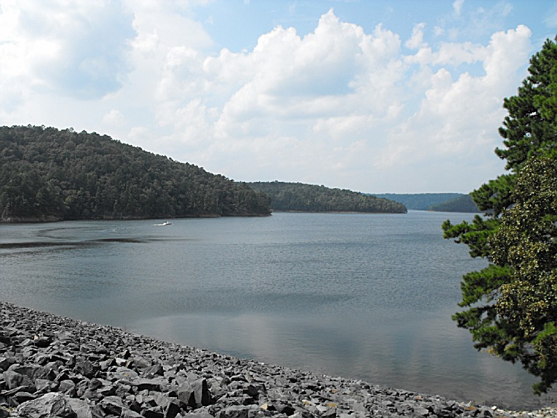