KUMBRABOW STATE FOREST
Kumbrabow State Forest is located along the western edge of the allegheny Highlands atop Rich Mountain. The 9,474 acres of forest range from 3,000 to 3,930 feet above sea level, making Kumbrabow the state's highest forest. Acquired in 1934, the forest derives its unusual name from the three prominent families, KUMp-BRAdy-BOWers, who were instrumental in the purchase of the land.
The forest is operated by the multiple-use concept which provides recreation and watershed protection, while practicing the principles of forestry and wildlife management.
Through good management practices, Kumbrabow is a showcase for stands of black cherry and red spruce. Diverse habitat has made black bear, turkey, deer, grouse, and bobcat sightings common to visitors throughout the year. Mountain laurel and rhododendron are abundant and surround the majority of several pristine streams, creating beautiful scenic views throughout the forest.
Kumbrabow State Forest facilities include fully equipped pioneer cabins, campsites, bathhouse with laundry, and picnic areas.
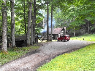
CabinsOvernight guests at Kumbrabow State Forest may select from among six completely furnished Pioneer cabins and cottage. Five cabins were built in the late 1930's by the Civilian Conservation Corps, the cabins feature stone fireplaces, wood burning kitchen stoves, gas lights, and refrigerators. Cabins have no running water, however pit toilets are available. Water may be drawn from the cabin area wells.
All cabins are equipped for housekeeping including cooking utensils, dishes, flatware, bed linens, towels, and outdoor charcoal grills
Pioneer cabins are open the second Friday in April to the first week of December (last day of deer rifle season).
Check-in is at 4:00 p.m, and check-out 10:00 a.m. NO pets are allowed in the cabins or cabin area A bathouse is located at forest office for cabin guests, and cots are available for an additional charge
Cottages
* 1 Three Bedroom Cottage * equipped the same as the pioneer cabins * gas range top * fully accessible * cots available at additional charge * NO pets are allowed in the cottage or cottage area * sleeps up to eight people * Pine semi-cathedral ceiling and walls set off by a stone fireplace in the spacious living room add to this unique mountain experience
The Cottage is open the second Friday in April to the first week of December (last day of deer rifle season).
Another option for overnight visitors is the Mill Creek Campground. The beautiful campsites lay in pristine settings near patches of Rhododendron and a native brook trout stream. Features at the 13 site campground include
* picnic tables * fireplace * drinking water * pit toilet facilities * coin operated shower and laundry located at forest headquarters * Firewood and ice are available at headquarters during office hours
The campground is open Mid April through deer rifle season.
All sites are rented on a first come, first served basis, and only one tent or trailer is allowed per site. Families may have one or two small tents in addition to the main unit.
R.V.'s longer than 20' may encounter difficulty in finding suitable sites. A self-registration and fee collection station is located in the campground.


 Share Your Kumbrabow State Forest Photos (click here)
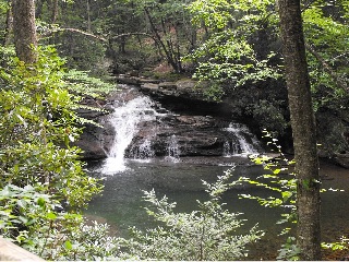