GOLCONDA MARINA STATE RECREATION AREA
Golconda Marina is located in the southeastern portion of Pope County along a scenic stretch of the Ohio River at Golconda, IL. The 274-acre site is a full-service boat marina with 206 slips. The marina serves as the gateway to the Smithland Pool area of the Ohio River. Smithland Pool, a 23,000-acre recreational area of fingered tributaries off the Ohio River, is recognized as one of the finest fishing and boating areas in the nation.
The marina marks the culmination of a concerted effort by several conservation groups to bring a recreational service facility to Golconda. Originally developed as a project of the Lusk Conservancy District, and completed under a joint venture between the U.S. Army Corps of Engineers and the Illinois Department of Natural Resources, Golconda Marina opened in the spring of 1988 as a multi-million dollar facility. It is one of the more modern marinas on the Ohio River.
The site where the marina is located was created in 1937 when barrow dirt from this area was used to build the flood wall around the town of Golconda. The resulting pit formed a water impoundment area that offered excellent trapping and fishing opportunities.
A large bluff located on the north side of the marina is called Rauchfuss Hill. The site also has been known as Steamboat Hill, because it offers the best location to watch the steamboats go up and down the Ohio River. The U.S. Forest Service obtained ownership of the bluff and built a camping area overlooking the Ohio River. It is now owned by the Illinois Department of Natural Resources. This area offers a picnic area and a hiking trail up the historic steps on the south bluff which is registered with the National Historical Society.
Another hiking trail will be built off the old railroad bed which is 3300 feet long. This trail will be rebuilt up the east slope this winter by the Ohio River
The federal government, which has primary jurisdiction in the Smithland Lock and Dam project, leased land and water acreage to the State of Illinois for public park and recreational purposes in 1985. The area, which includes boat ramps, an access road and a parking lot, is now owned by the Illinois Department of Natural Resources, which leases the marina to a private concessionaire.
Cottages and Cabins
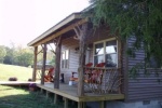
Southern Illinois Cabins with all amenities, surrounded by The Shawnee National Forest in Southern Illinois. All cabins have air conditioning, heat, kitchen including stove, frig, microwave, coffee maker, toaster bathroom with shower, screened in porch, electric fireplace, satellite tv with HBO and DVD, all linens, cookware, plates, utensil, outside grill and picnic table.
11 miles from park*
BBs / Inns
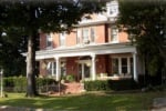
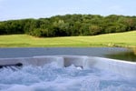
Built in 1914 in a picturesque rivertown, the River Rose Inn Bed Breakfast is unique and gracious with spectacular views of the dazzling Ohio River. Enjoy our luxurious accommodations and our gourmet breakfasts. Relax in the formal living room or cozy parlor on the second floor. Swim in the inground pool or enjoy the private jacuzzi spa.
11.1 miles from park*
Cottages and Cabins
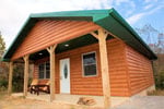
Enjoy a getaway to nearby Southern Illinois with Shawnee National Forest Cabins. Rustic log cabin rentals with modern comforts such as hot tubs, Wifi and satellite TV located near Garden of the God in the Shawnee National Forest.
16.6 miles from park*
Cottages and Cabins
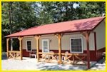
LARGE 2 and 3 bedroom private CABINS located near many of the major ATTRACTIONS of the Shawnee National FOREST and the surrounding Southern ILLINOIS area. All cabins offer incredible VALUE as they are fully furnished with everything needed including full kitchens with cookware, microwave, liens, fire pits and wood, outdoor grill, satellite TV and even FREE internet. Open all seasons
0.3 miles from park*


 Share Your Golconda Marina State Recreation Area Photos (click here)